Monday, May 30, 2011
Old Sturbridge Village
Today we spent all afternoon at Old Sturbridge Village. It is a museum village that has been created with many old New England buildings from the early 1800's that have been moved and restored to make a village effect. There are old barns, farm houses, saw mill, grist mill, meeting houses, bank school house and on & on. It sits on probably about 40 acres. They have working demonstrations of the period along with a couple of buildings that show the progress from the early 1800' until now. It is a very interesting place.
Field Stone Farm
Sun. we went to Field Stone Farm near Ware, MA the home of my cousin Jack Soper. We had a very enjoyable afternoon visiting cousins David, Wally, Jack and Ruthie Soper and their families. We enjoyed the home grown all natural beef raised on the farm as well as the Mai-Mai fish that Ruthie's friend Don had brought from Florida. We also had all of the usual picnic side dishes. Field Stone farm is an old New England farm dating back to the 1800's. It consists of a large 3 story house and barn that are connected as one unit. Jack has been restoring the house as closely as he can to it's originality. He has made a lot of progress since we last saw it 7 years ago. He still has one room on the main floor, one room on the second floor and the third floor to do. Due to the poor Verizon broadband reception here I can't get any pictures downloaded.
Sunday, May 29, 2011
Sturbridge, MA
Fri. morning we left Lancaster, PA headed NE on US 222 through the fertile rolling hills covered by the many dairy farms and small fields farmed by either Amish or English farmers. After passing through Reading the Rte became mostly two land passing through many small towns with lots of traffic. At Bethlehem we turned north on US 33 to Scotrun, PA located in the Pocono Mts near the New Jersey state line. After traveling only 125 miles we stopped at the Outdoor World Campground where we set up under the towering trees on the mountain side for a relaxing afternoon and evening. Sat. morning we headed NE on on US 209 through a state park with a river on our right and the mountains on our left. At Milford we turned east on I-84 entering New York and the Shawangunk Mts we reached elevations 2500 ft. It was then into Connecticut passing through Danbury, Waterbury and Hartford before entering Mass. We are staying at the Outdoor World at Sturbridge, MA just past the Conn. state line.
Thursday, May 26, 2011
Joseph
Today we went to the Sight & Sound theater for the matinee of Joseph. This is a 2 hr. production of the bible story of Joseph. It is done with live animals and a wrap around stage. It is done with some music and a tad of humor. A very well done production. This evening we had a tornado warning so we went to the storm shelter until it blew over. Quit a bit of rain but nothing else.
Wednesday, May 25, 2011
Lancaster, PA by segway


 Today I went to downtown Lancaster where I took a 1 1/2 hr tour of the city by Segway. I did this in Mt. Dora, Fl about 6 weeks ago what a great way to see an area. I'm hooked!!! I was the only one besides the tour guide so it was a very personal tour. We went down Prince St past the art studio's. Past a really old cemetery where a Mr Fulton is buried stopped at Penn Square in the middle of down town. We passed the Lancaster Quilt & Textile Museum, St. James Episcopal Church.
 We passed through Central Market probably the oldest farmers market in the nation. The Fulton
Theater, some of the dozen or so pianos that are placed downtown and decorated by sponsoring organizations. They are there for people to just stop & play. In the fall they are auctioned for a fund raiser. I learned that Lancaster was an important part of the under ground railroad used to move slaves from the south to the north to freedom. I also learned the the difference between a cemetery and a grave yard is that the graveyard is by a church and is for church members and a cemetery is located away from the church and is for all people unless they have committed suicide. Yesterday was pretty much a road trip day. We started out by going to a huge flea market/ farmers marker called Rooks. Much to my surprise after about an hour Nancy said enough of this it's to big and to crowded. We then drove further north to Manheim, PA and the Pennsylvania Dutch Camp ground to check it out. We then headed 34 miles east to the town of Blueball and the Shady Maple smorgasbord for lunch, a huge place that seats 1100 people. We are going to have to quit this or we will gain the weight back that we had lost this winter. From there it was back southwest through down town Lancaster and to the Circle M Campground
Monday, May 23, 2011
Ephrata Cloister
 Today we went to Ephrata Cloister a religious community started in 1732 by Conrad Beissel. Conrad born in Eberbach Germany in 1691 came to the new country at the age of 29 to seek refuge from religious persecution in Germany. William Penn had acquired a large tract of land in what is now the Lancaster area and promised freedom from religious persecution to all. After 12 years in Pennsylvania some of it as leader of the Brethern congregation he sought solitude in the forest to continue his spiritual pilgrimage to join God in Heaven.
 Two issues important to him were that Sat. be the main day of worship and to unite with God left no room for an earthly marriage. Others fallowed and by 1750 Ephrata consisted of 80 celibate brothers & sisters known as the Solitary. About 250 families that lived on nearby farms chose Conrad as their spiritual leader but were unwilling to make the sacrifices he demanded to become part of the Solitary so they were known as Householders. They contributed funds, produce and assistance to support the Solitary Brother & Sisters. Conrad believed that there was no food or sleeping in Heaven. Therefor The Brothers & Sisters ate one meal a day and worked long hours and had private time for meditation with brief periods of rest. The Brotherhood operated the only printing press west of Philadelphia for nearly 50 years beginning in 1743. The Sister did
 musical composition and German calligraphic writing. In 1813 the last celibate member died leaving the Householders to maintain the property and the faith. They formed the Seventh Day Baptist Church continuing to live and worship at Ephrata until 1934. In 1941 The Pennsylvania Historical & Museum commission acquired the property and began a 25 year restoration project. These buildings and furniture are all original except for the floors. The large building was the Sisters quarters and the building connected to it on the right is the meeting room. The picture that looks like a chalet is the kitchen building It has a lower floor that is where the kitchen was. The cemetery is where all of the Brothers & Sisters are buried along with children and some of the original Householders. The other picture is of the printing press. www.ephratacloister.org
 Mid afternoon we stopped at the Udder Place in Ephrata where we each had a sandwich and Nancy had a root beer float and I had a strawberry ice-cream soda. As you may have guessed this is an ice-cream parlor that has the walls covered with old ice-cream signs and a huge selection of old ice-cream scoops.
Sunday, May 22, 2011
Amish country
 Today was a cool overcast day. About noon we went to the Lancaster co. visitor center. While there we took a van tour through the rural areas. Sun. is a day of rest for the Amish & Mennonites so most of the dutch restaurants and all of the shops are closed. It is however a great day to see the Amish out and about as for 1/2 of them it is their every other week church day and for the others it is a day for visiting. We saw young men in their open courting buggies either on their way to pick up a young lady or she may have been riding with him already. We saw farm yards full of the covered Amish family buggies where they had gathered for the 3 hour church service.


We saw many families traveling the rural roads going for the Sunday visit. We also saw many mules grazing in the grassy fields near the barns It is a day of rest for them too. About 3:30 we went to Plain & Fancy near Intercourse for another family style meal. We were seated at a table for 10 with a couple from Wis.along with their daughter and husband from Wis and daughter and husband from Virginia and a young couple from about an hour away. Meal was good but not as good as the meal at Good & Plenty Thur. evening. As we traveled the rural roads home we enjoyed the beauty of the many flowering shrubs, Irises and well manicured Amish farm yards and gardens.
Rain Rain

 Friday was rain off and on all day long. When we went to Wal-Mart we saw 6 or 7 mini motor homes painted with the end is coming May 21st. There seemed to be a crowd around. They were leaving when we left and we later saw them diving through downtown Lancaster slowly. I guess they missed their prediction. I wonder what they will do now that they have given all of their possessions to the Rev. Camping's cause. Sat. was a sunny day and we simply sat around the motor home enjoying the day and visiting with people. The one picture is of the Lancaster city square.
Thursday, May 19, 2011
Lancaster, PA
This morning we headed north on US 13 stopped for fuel a few miles down the road. Diesel had dropped a whole 6 cents a gallon since our arrival a week ago now $3.99 a gallon. There went another $400. Traveling past more farm land with wheat and growing corn, we also passed a Perdue & Tyson chicken processing plant. As we traveled into Maryland it became more farm like with larger fields. After 40 miles or so and passing through Salisbury we entered Delaware. As we came nearer Dover the traffic became noticeably heavier but we still had the flat sandy farmland interspersed with trees. At Dover we entered Us 1 a toll road it took 2 $4 tolls to cover the 50 miles to the Newark, Wilmington, Delaware area. That was a lot cheaper than the $28 that it cost us to cross the Chesapeake Bay bridge last week. We then went north on I-95 for about 5 miles and managed to get into one traffic jam. It took about 30 minutes to travel that distance before heading NW on US 41 into Pennsylvania. Another 50 miles traveling the rolling tree cover hills and farm country brought us to Lancaster where we are staying at Outdoor World Circle M campground just to the south of Millersville. We traveled about 230 miles today. We decided we wanted some good Dutch cooking so we went to the Good & Plenty just east of Lancaster. You eat family style and we were seated at a table with 6 ladies from Harrisburg. We started out with coleslaw, chicken salad, chow-chow, white & wheat home baked bread, white butter and apple butter. Next they brought a bowl of creamy mashed potatoes, gravy, cooked pickled beets, corn, buttered noodles. Then a platter each of roast beef, fried chicken & pork tube sausage. For desert there was tapioca pudding, cheese cake, blueberry crumb pie, shoefly pie & ice cream. Since we are trying to watch what we eat I made sure that I watched every bite as I slowly sampled every thing except the ice cream (opting for a second bowl of tapioca) stuffing myself until I was about to burst. We arrived this afternoon in the rain and it has rained off & on since.
Wednesday, May 18, 2011
Ker Place
 The Ker Place is a Federal house located at Onancock, VA.
It was finished in 1803 for a prosperous merchant farmer named John Shepherd Ker and his wife Agnes Corbin Ker. As all houses on the Peninsula is not particularly elegant but it is a huge house. Due to the relatively inaccessibility of the peninsula marble and stone to build elegant houses wasn't used. Instead they used plaster for fire place & cornis decorating. They did fax painting to resemble marble on the trim around the floors. They also fax painted the doors and wood work to look like fine mahogany. The house has had only 2 owners with the third being Historical Society. It has easily been restored original condition.

 The outside wood trim, doors and windows are all original. The basement floors and walls are brick. the rooms there would have been servants quarters. John died at age 34 from consumption and
Agnes a few years later at 36 also from consumption. The two children lived with a cousin at the house until it was sold to the second owner years later.

Tuesday, May 17, 2011
Wachapreague, VA
 Wachapreague is a fishing village located about 10 miles north of where we are camped. It is reported to be the best flounder fishing on the east coast. They also have a lot of clams, crabs, oysters & shrimp here. It is home to the Island House restaurant that is one of the best places on the peninsula to eat. We have eaten there twice and the shrimp, flounder and crab cakes have been delicious.
 They seem to feature breads made with sweet potatoes. One night we had sweet potato corn bread and this evening it was sweet potato biscuts. I was a little apprehensive at first but they are very delicious.
Barrier Islands Center
 Today we drove a few miles south along a back road to the small fishing village of Willis Wharf. We then got back on US 13 for a few more miles the the Barrier Island Center at Machipongo. It is located at what was once the poor farm. A gentleman there who is a native that was born on Hog Island gave us a very interesting and informative tour of the poor farm facilities and also the history of the barrier islands. The rooms of the main house contain the museum dedicated mostly to the history of the Barrier Islands off the east side of the peninsula. The Barrier Islands were inhabited at one time and were used by the wealthy from Washington DC, Baltimore and other big cities further north. There were many hotels, resorts and hunting clubs located on them as well as families that had lived for 2 or more generations on them.
 The forces of the wind and water have caused the islands to move over time. Similar to sand dunes but at a slower pace. A storm in 1933 washed away the 15 to 20 sand dunes that protected them. This also destroyed many of the resorts. The families that had lived there all their lives could see that they were no longer going to be able to live there so they began moving to the mainland. Some of them even jacked their houses up, loaded them on a barge and moved them to the mainland. Some of them are still located at Willis Wharf. The water ways in and out of the barrier islands were used over time by pirates and other merchants to smuggle goods into the US to avoid taxes and tariffs. The barrier islands are no longer inhabited and are now owned by the government to keep them from being developed. NASA does have a rocket facility located on Wallops Island

Cape Charles, VA
 Mon. we journeyed about 25 miles south to the town of Port Charles located on the bay side close to the south end of the peninsula. Like most of the towns on the east shores (peninsula) it is a small town that has a marina. It was a town where the more affluent came as the bay side of the peninsula has sandy beaches. There are a lot of big old houses some of which have been restored and some in need of restoring. There are many more that have been well maintained. The sea side is mostly marsh with rivers feeding out through the barrier Islands to the Ocean. Returning home we stopped at a fruit stand in Exmore to purchase fresh strawberries & asparagus.
Sunday, May 15, 2011
Onancock, VA

On Sat. we went to the village of Onancock located on Onancock creek (a deep water creek) about 4 miles from the Chesapeake Bay. It is located about 20 miles from the camp ground on the Atlantic Ocean side. In early times it was an important port for steam ships transporting farm produce and other goods. We had planned to take the ferry to Tangier Island accessible only by water or air but the ferry wasn't running. It seems that things don't really start to much until Memorial Day weekend.
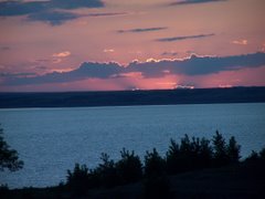
Late evening when the tide came up it got high enough that it just about came into the camp ground. The locals say this was because of the full moon and strong winds that we had from the east. They say it will occasionally cover the camp ground with water. There are not sandy beaches here instead there are clam beds where you can rake clams when the tide is out. The picture was taken today from the motor home and the tide was out. As you can tell from the surf it was another windy day.
Friday, May 13, 2011
Chincoteague, Island


Chincoteague Island is about 40 miles on up the peninsula near the Maryland border. It is a small fishing town and tourist destination. Just before entering the island we pass by the NASA Wallops Island Flight facility. It is the nations oldest most prolific rocket launching site and where the US space program began. Just beyond Chincoteague is Assateague Island National wildlife Refuge. This refuge is most famous for the wild ponies that live on the island. The Chincoteague volunteer fire department began rounding them up about 80 years ago and selling some of the colts as a fund raiser. They now own the ponies and sell enough colts in July each year to keep the herd at no more than 150 adults that their lease with the refuge requires. The refuge is also a stopping of point for huge flocks of snow geese as well as about 150 other migratory birds, eagles, ospreys, deer, Japanese elk and a squirrel found only on the island. There are also white sandy beaches where we saw many people fishing today but in the summer are covered with sun bathers. This is the southern part of the island and is only about 1/4 mile wide with the beaches on the ocean side and marshes on the west side. You can drive in this area the picture is taken from right in front of where I parked the car.
Quinby, Virginia

 Thur. morning we left Williamsburg headed southeast on I-64 at Newport News we went through a long tunnel under the James river. We had to stop at a checkpoint where an inspector wrote down our licence no's and checked our tow car connections and made sure that we turned off the valve at the propane tank. After about a mile we surfaced traveling on int Norfolk, VA We then turned north on US 13 where we passed over the 20 mile Chesapeake Bay bridge There were also 2 long tunnels here. I assume that is where the ships pass to enter the bay. After stopping at the welcome center we traveled another 25 miles up the peninsula to the small town of Quinby, VA where we are staying at Virginia Landing a Thousand Trails Preserve on the shores of the Atlantic Ocean.
  Unlike the hilly tree cover hills and mountains that we have been in the peninsula is flat and sandy with small fields of wheat. I would guess it to be no more than 2 miles wide in places. The middle picture is of a crabbing area less than 100 yards from our motor home.
Wednesday, May 11, 2011
Williamsburg, VA
 We left the KOA at Ona W VA around 9AM headed south southeast on I-64/I-67 a winding rte taking us into the Appalachian mountains. After about 100 miles I-64 turned east and we went over the mountains into Virginia. As we would climb to elevations over 2500 ft. the trees would noticeably became less lush green looking as many of them were just budding out. Traveling on east into Virginia the terrain became less mountainous and we began to see many meadows with cattle in them. At Charlottesville I-64 turned to a southeasterly direction. As we neared Richmond the traffic began to get heavier and stayed that way to Williamsburg where we stopped for the night at an Outdoor World Resort that we have a membership at.
Tuesday, May 10, 2011
Charleston, West Virginia
Tonight we are at a KOA Kampground (ouch one night here is more than we spent going to Campbellsville) just west of Charleston, W VA. After a very enjoyable 4 days with friends Paul & Mary we left Campbellsville about 10:30 this morning headed north east toward Lexington, KY traveling through the rolling green Hill country. As we passed to the south of Lexington we passed some of the horse farms in the blue grass country. I always enjoy seeing horses and some of these horse farms are really plush looking. Some of them seem to have for sale signs on them, but not as many as in the Ocalla FL area. We then headed east on I-64 through the hill country of eastern KY. We stopped at the welcome center as we entered west Virginia. There we found out that it is not as easy to find campgrounds that can handle a 40 ft. rig. We decided to stop early at this KOA rather than drive another 2 hrs to find something suitable for us. There have been severe storms in the area all evening but they seem to be going on either side of us and we are just having thunder showers.
On The Road Again

 A week ago today on Tues. morning around 11AM we departed Sebring, FL on our summer trip in the motor home. It was the height of the love bug season so when we stopped at Ashburn, GA for the night the front of the coach was covered with black bugs and bug juice. Since love bugs have an acid in them that will ruin a paint finish if not removed promptly I spent nearly an hour scrubbing them off. They are harder to remove than grass hoppers or honey bees. We stayed at a PassPort park about 5 miles west of town. It can best be described as a redneck RV park. IT was on a golf course. The camp host left a golf cart with us so we could tour the golf course and lake. In spite of first impressions it was really a nice quite park that we would stay at again. On Wed we continued north on I-75 through GA between Atlanta & Chattanooga we saw a few places where the tornadoes had passed through. The trees were all broken and strewn around like match sticks on area had to be over 1/4 mile wide. We spent the night at another PA park at Jamestown, TN again a very nice RV park that we would return to. Thur we continued on north & west arriving at friends Paul & Mary Osborne's in Campbellsville, KY. While here we park in the drive way between the office and garage. Sat. was the annual Kentucky derby Party that Mary hosts for family and us. Mon we drove to Louisville where we visited cousin Barbara Wheeler. Sat morning Paul & I drove out to Green River Lake to look at the high water. The RV park is under water and the water is 1/2 way up the picnic shelter and basketball goals. We have seen very little field work that has been done so far.
Subscribe to:
Posts (Atom)