Friday, September 25, 2009

Fri. Sept. 25th.

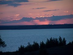
Today we drove south on US 101 about 45 miles to Tillamook, OR. Along the way we had many beautiful views of the surf washing in around the various rock formations and beach's. The route isn't always along the ocean but at times you are in the forest winding around hills really a very beautiful drive passing through many small seaside towns.
After arriving in Tillamook we went to the Tillamook cheese factory. This is a 100 year old co-op owned buy the dairy farmers in the area. They make cheese, yogurt & ice cream.
This is quit a tourist attraction in the area. we were surprised by the number of people there. This area has 90 inch's of rain annually so the grass grows very lush and it doesn't require a lot of land to support the cows. After leaving there we traveled west on what is called three capes scenic loop past pastures full of Holstein and Jersey dairy cows and then up into the coastal mountains.to Cape Mears light house. This light house is the shortest one on the Oregon coast being only 37 ft. tall. Like most of the light houses it is no longer in use. I did learn from the man that was there that the oil lamp that was in them wasn't that big. The lens in this one magnified the light 87%. I also learned that each light house beacon turned at different rates of speed. That way by timing the rotation the ships captain could consult his navigation maps and know where he was located as well as knowing were the shore line was. We had planned to continue on around this loop to two more capes but yours truly must have taken a wrong turn and we ended up back in Tillamook. On the way back we stopped in the small coastal town of Wheeler for an early supper of Prawns & chips. I thought this was kind of neat since my mothers maiden name was Wheeler.

Thursday, September 24, 2009

Seaside, OR Sept. 24th.


Yesterday was a cold dreary day, about 25 degree's cooler than the day before and misty so we stayed pretty close to the RV Park and did a few repairs and caught up on cleaning etc.
This morning we headed back north on US 101 to Astoria where we crossed the 3 1/2 mile long bridge across the Columbia River into Washington ending up at Cape Disappointment south of the town of IlWaco, WA. This is the location of the Louis & Clark Interpretive center where Lewis & Clark ended their journey at the point that the Columbia River meets the Pacific Ocean. After exploring the area the people of the expedition voted to go to the south side of the river for their winter encampment. This is the site of Fort Clatsop that we visited on Mon. The reason they went across was that the weather was better, food was more plentiful and they also make the salt that they needed to preserve the meat supply, this was done here at what is now Seaside. Cape Disappointment Light House is also located here on the north side of the river. This is the oldest light house still in use on the coast. Also located a short distance around the cape to the north is the North Head light house that is no longer in use. I found it interesting that this light house had two large light house keepers residences. Due to remote location these families had large gardens and raised chickens etc. The daily duties were to carry buckets of oil to the light house to keep the lamps burning and to keep the mirrors clean and shined for maximum light. On the way back we stopped in Astoria and went through the historic Flavel House built by a River bar captain for his family in 1886. He had other business interests in the area and had become the wealthiest man in Astoria by that time. The house was built at a cost of $37000, had electricity, indoor plumbing and flush toilets. There is a Sequoia tree still standing that was there at the time the house was built

Wednesday, September 23, 2009

sept. 22nd. Seaside, OR


Today we went north on US 101 about 15 miles to Astoria, OR the first established town west of the Mississippi. On the way we stopped at Fort Clatsop the site of Lewis & Clark's winter encampment at the mouth of the Columbia river and the Pacific Ocean. The fort is named after the Indian tribe on whose land it was erected. The lower picture is where they landed their wooden canoes. From there we went on to the Astoria Column erected on Coxcomb hill. From here you view Oregon, Washington, the Columbia River and the Pacific Ocean. Next it was the Columbia River Maritime Museum to see & learn about the navigation and dangers of the Columbia River where it meets the Pacific Ocean. Every ship that goes in or out through this
area has to be boarded by one of about 40 trained and experienced river pilots to navigate it through these very dangerous waters. Over the years there have been many ships wrecked in area. This evening we went to the beach in downtown Seaside and enjoyed a very beautiful sunset.

Monday, September 21, 2009

Sept. 21st.


Today was a beautiful 80 degree day that we spent exploring Seaside and Cannon Beach located 8 miles south of Seaside. Several of the people we talked to said to enjoy the weather as this was not normal for here. We started out diving to the Pacific Ocean located a couple of miles west from the RV park. We then parked near the beach down town and watched people going out to the beach. We walked the beach promenade and went into the Harbor seal aquarium were we saw the harbor seals and several small aquariums filled with specimens of local marine life. This is an old aquarium but very interesting. We then looked in some of the shops and ate lunch at a small cafe. In the afternoon we drove south on US101 about 8 miles to the town of Cannon Beach. After driving about 1 1/2 miles on a narrow winding road under the giant white spruce trees that covered the road like a tunnel we arrived at one of the most photographed areas on the Oregon coast at Ecola State Park. From here we could see the Tillamook lighthouse located between Seaside and Cannon Beach but inaccessible from land. We could see Haystack Rock located to the south at Cannon Beach and many other rock formations. Driving another 1 1/2 mile through the same kind of tree covered road we arrived at Indian Beach where we enjoyed watching the surfers and other beach goers.

Sunday, September 20, 2009

Seaside, OR

Here we are just a few blocks from the Pacific Ocean in a Thousand Trails RV Park in Seaside, OR. This morning we left Crooked Creek Ranch traveling west through the country side past the Alpaca farm to US 20 at Sisters, OR. From there we traveled west through the Cascade Mountains over Santiam Pass with 7800 ft. Mt Washington on our left. Then it was an 11 mile long winding 6% down grade on the other side. After we descended we drove along the Santiam River winding winding our way toward Albany, OR located in the fertile Wyamet Valley. There we turned north on I-5 traveling through the valley to Portland where we turned NW on US 26. We then traveled through the Clatsop State Forest ending up on US 101 at Seaside. I now know why Oregon has a pine tree on there license plate. After traveling clear across the middle of the state from east to west I believe nearly the whole state must be covered by some kind of evergreen tree and a sign that says curve 35 MPH.
I am again very disappointed with the Thousand Trails Park we are in. For what it cost to join and the cost of the annual dues, plus the glamorous descriptions and pictures in the preserve guide book I expected more of a resort type setting. Instead they all seem to me like second rate poorly maintained parks. If any of you RVer's that read this blog are thinking about joining Thousand Trails I would sure like to visit with you first. I wish we had visited with someone before we wrote the check. Oh well as Nancy says we did it so get over it.

Saturday, September 19, 2009

Crooked Creek Ranch, OR


The River Rim RV Park is located about 8 miles north of Redmond, OR in a development area called Crooked River Ranch. It is a desert setting with the Crooked River running through it. The river is about 250 ft. below the flat sagebrush covered and scattered pine tree desert above. The cliffs and jagged rock walls are nearly vertical. This morning we drove about 25 miles south west to Sisters, OR. Along the way we went through an irrigated valley that had lots of small ranches along the road, one of them was the Crescent Moon Alpaca Ranch. I have never seen so many alpaca's, they numbered in the hundreds. When we arrived at Sisters we found it to be a trendy touristy town. While there we walked through a street fair.

Friday, September 18, 2009

Redmond, OR


This morning after leaving Baker City, OR we traveled Southwest on OR 7 and US 26 through the Umatilla National Forest up mountains down mountains and around winding curves and then through
mountain meadows along the Powder River. Traveling west Near Prairie City we left the forest and entered into the same kind of terrain only the mountains were covered with grass and sage brush and the meadows also had green fields of alfalfa growing in them. We passed many ranches with names like Widow Creek Ranch & Long Box Ranch. We saw many herds of cattle grazing in the meadows. About 30 miles west of John day, OR We went up a sharp winding road through tall steep fossil beds. After that it was more of the same and then west of Mitchell we entered the Ochoco National Forest exiting it near Prineville and entered what they call high desert area to Redmond, OR where we are staying at the River Rim RV Park. At the edge of the park it is a sheer drop off 250ft. to the Crooked River below. I have never went around so many curves at 30 MPH as we did today. It took us about 6 hrs to travel the 210 miles.

Thursday, September 17, 2009

Baker City, OR

After spending a leisurely day yesterday at the RV Park playing cribbage with John & Mary and just relaxing we headed south on ID 55 this morning. Driving through the valley we passed herds of cattle grazing on the lush grass.
Leaving the valley and entering the Packer John State Forest the tree covered mountains were absolutely beautiful with the morning sun shining on them.


After topping the mountains at about 5600 ft. we traveled along the white water rapids of the Payette River as we descended to an elevation of 2500 ft. About 1/2 way down we left the forested mountains and traveled through grass covered mountain grazing lands before turning west at Horseshoe Bend on ID 52. As we neared the town of Emmett we suddenly entered into flat rich irrigated farm lands where we saw sugar beets, corn, onions and msc other crops being grown. We entered Oregon at mile marker 356 on I-84 and soon after heading north we left the fertile fields and began travelling up & down long hills covered with dry brown grass. At mile marker 302 (Baker City) we turned off and went to the Oregon Trail Interpretive center where we spent 3 hrs viewing the displays about the Oregon Trail. We also saw two very informative films about the Donner expedition and the entire passage of the Oregon Trail. Tonight we are at the Oregon Trails RV Park at Baker City

Wednesday, September 16, 2009

Cascade, ID


Yesterday John & Mary took us around Cascade Lake to an area called Tamarack. Here some one had started developing a ski resort & community 4 or 5 years ago. They lost financing and it development was shut down a couple of years ago. There is a huge hotel that was under construction along with million dollar houses, lodges etc just setting there empty. There are some house occupied and the golf course seems to be open.
We then went on north on US 55 to McCall for lunch and the on north on a county road by Lake Payette and on into Nes Perce National Forest to a place called Burgdorf Hot Springs. Here for $5 a day you can spend the day in the hot springs pool. This place is so far up into the mountains that they don't even have electricity,they do have rental cabins however. This place is junky with some buildings falling down and looks like an old abandoned mountain place(top picture). We then went east and 16 miles past the end of the pavement we came to the old gold mining town of Warren see pictures. There are still people living here and there is a tavern so I guess you can't call it a ghost town. There is no electricity here either, however we did see one house with a DishTV dish on the side of it.

Monday, September 14, 2009

Arrowhead RV Park Cascade ID


This morning after a call to the manufacturers service dept. it was a quick fix and the leveling jacks retracted and we were on the road about 8:30. It was back through Missoula on US 93 and west on US 12 along the Lochsa River some 100 plus miles through the Clearwater National Forest to Kooskia ID. This was a winding road with about 25 miles of road construction that took about 4 hrs to traverse but it sure was a beautiful drive. It was then south on ID 13 through a large valley with ranches and some farm land. Most of the route so far had elevations ranging mostly 1500 to 2500 ft up to 5500 ft over the mountain passes. At Grangeville we turned south on US 95 driving through grass covered mountains and then into tree covered mnts. with the Salmon river on our right side. At New Meadow we turned onto ID 55 traveling along the Payette River through huge meadows filled with cattle and by the time we got to Cascade we were back int0 the forest again and had climbed back up to around 5000 ft. elevation. Our friends John & Mary Feilding stay here in the summer so they were waiting for us when we arrived. Having lived east of the Colorado Rockies all of my life I didn't realize that this far north the elevation of the Rockies would be mostly 1500 to 2500 ft. This whole day has been such a beautiful drive with either a river or a mountain stream on one side or the other for most of the entire 290 miles. It was a time consuming drive taking 8 hrs because of the winding roads.

Sunday, September 13, 2009

Sun. Sept 13th


After having brunch at the Montana Club we drove south of Missoula on US 93 about 8miles to the town Lolo where the Travelers Rest State Park is located. They say this is the only site that can verify Lewis & Clarks encampment because they have dug up artifacts etc. to document it. They were having a rendezvous this weekend so we saw buffalo hide tanning, flintlock rifle, parflech artist demonstrations along with beading and many others. Also they have a small museum located here that has many beaded Indian things and a display of fire in the fighting in the past.

Saturday, September 12, 2009

Missoula MT


Jim & Mary's RV Park is such neat well maintained RV Park with flower gardens all over that we decided to stay until Mon. Really our leveling jacks won't retract and this being the weekend there being no service available we don't have any choice. Today we drove north on US 93 about 30 miles to St. Ignatius Mission, however upon arriving we found a wedding in progress so didn't get to see the inside of the church. We drove on north about 15 miles to the Ninepipes Museum of early Montana located on the Flathead Indian Reservation. Here we saw a very large collection of Native American bead work, spurs, saddlery and many many old photos. This area is in a huge valley in the Rocky Mountains north of Missoula. The picture shows some patches of snow in the high mountains to the east of the museum. It looks like all the snow didn't melt this year to help fill Lake Sakakawea.

Friday, September 11, 2009

Missoula, MT

This morning when we left Lewistown to avoid road construction on US 200 we went north on US 191 and then west on MT 81 through the Judith mountains Then back south were we again got on US 200 toward Great Falls, MT. Along this route we drove past huge fields of cut wheat. There wasn't a cloud in the sky and you could see forever, I see where Montana gets the Big Sky nick name. At Great Falls we turned south on I-15 Traveling along the beautiful Missouri River Canyon through the Big Belt Mtns. Helena MT, sets in a huge valley. Coming down into it from the north I told Nancy that it didn't look like a very big town, but it turned out to be fairly good sized. At Helena we turned west on US 12 over MacDonald Pass (elev. 6340ft.) At Garrison we turned NW on I-90 traveling through more mountainous area arriving at the beautiful Jim & Marys RV park in Missoula mid afternoon.

Thursday, September 10, 2009

Lewiston, MT

This morning we left Hazen Bay around 8 PM. After stopping in Hazen for fuel, propane and a stop at city hall we were on the road at 9:30. It was west 8 miles to Beulah and then south on us 49 to I-94 where we turned west traveling into the badlands of western ND. At Glendive, MT we crossed the Yellowstone river and turned onto US 200 west traveling through the vast Montana prairies where we didn't see a town for 40 to 60 miles at a stretch. from Winnet on west we began seeing pine trees in the coulees. A little east of Lewiston we gained 1500 ft. in elevation and started seeing a lot of pine trees. The Yellowstone river that we crossed at Glendive is the major source of water for Lake Sakakawea along with water from the Missouri River that comes through Fort Peck Dame in Montana. We hadn't planned on traveling so far today but found out there aren't any camp grounds out in the prairies.

Wednesday, September 9, 2009

Another season ended

Fall is in the air and another season here at Hazen Bay has come to an end. The leaves on the trees are starting to change color and the geese that have been here all summer that have been flying noisily over head for a couple of weeks getting their young ready for the trip south have disappeared. The farmers are nearing the completion of the harvest of the earlier fall crops such as wheat & barley.
We had a very busy Labor Day weekend with 116 total camping units here. The weather was warm and very little wind. On Fri evening Friends of Hazen Bay had a Fleishkuekla fund raiser to raise funds to pay for the playground that was just installed. The event was a great success as they cooked 784 Fleishkuekla. There was also cotton candy provided by one of our campers along with many baked goods.
What is a Fleishkuekla you ask? Well it is a this very flat piece of seasoned hamburger wrapped in bread dough that is then deep fat fried. It is of Russian origin being brought to this area by the Russian Germans when they immigrated to this area. We have never seen them in any other part of the country but really enjoy them as they are very tasty.
We have enjoyed our 4th. summer here at Hazen Bay doing what we really like to do and doing it with people that we have came to consider as family and in an area of the USA that we really like. One can't ask for any more than that in their retirement years. We are so blessed to be able to do this and enjoy relatively good health. As soon as a package that we are waiting on arrives we will begin our journey back to our home in Sebring, FL hoping to arrive in time for Thanksgiving.