Saturday, October 31, 2009

This morning after a delicious breakfast of blueberry pancakes, sausage & juice we had a presentation put on by representatives of the Havapai-Apache Nation about their history. They are a tribe of about 2500 that live here at Camp Verde. After that our friends David & Beverley Simmons who live in Sun City went with us north on I-17 to Munds Park where they have a summer cabin. After enjoying a lunch at a cafe there we traveled down Shibbley road to Sedona. This is a 12 mile drive down a winding dirt rock covered road first through the ponderosa pine forest and then into the red rocks looking down on the town of Sedona as you continue winding your way on down the mountain.
If you can imagine driving on a road with rocks that regular car would probably scrape on going over them that took two hrs. to traverse with views like the pictures show then take that times 150% and you have the picture. This evening our group went to the Blazing M Ranch in Cottonwood for a cowboy supper and evening of country western entertainment.

Thursday, October 29, 2009

Camp Verde, AZ

This morning we left Salome, AZ about 9:30 traveling east on US 60 through the valley between the Harcuvar Mtns on the left and the Harquahala Mtns on the right. The cantaloupe fields in the valley had either been harvested or were being harvested. Nearing Wickenburg we left the valley and entered into the rolling hills covered with bushy desert vegetation and Saguaro cactus. On the edge of Wickenburg there are a couple of dude ranches, however the only thing I see for cattle to eat are the leaves off from the desert bushes. A few miles after leaving Wickenburg we turned east on AZ 74 and the cactus growth became more dense. Turning north on I-17 the terrain became much steeper as we traveled up a long pass to an elevation of 4000 ft. The mountains began to have grass growing on them and we saw some herds of cattle. A few miles from Verde Valley we began the long 6% slope down into the Verde Valley where we are staying at the Distant Drums RV Park while attending the Newmar Kountry Klub AZ State Rally.

Monday, October 26, 2009

Salome, AZ

Yesterday we traveled US 58 & I-4 across the Mohave Desert to Needles , CA. This drive takes you past the Joshua trees east of Mohave into the sage brush covered areas on to the east always with rocky desert mountains on the horizon in front and to the sides of you. We turned south on US 95 traveling about 45 through the rolling desert and then east on US 72 crossing the Colorado River at Parker AZ. It was then south on AZ 95 and AZ 72 to Hope , AZ . Driving east on US 60 after leaving the small desert town of Hope you see a sign that says "you are past Hope". After a short 8 mile drive over the Harcuvar Mountains we arrived at Salome, AZ where we will be staying until Thus. morning. One forgets after being along the lush coastal areas of Calif & OR that in such a short distance to the east there is this vast area of arid desert.

Saturday, October 24, 2009

California City, CA


Fri. around noon we left Morgan Hill after spending two weeks with Chris & David. We made a stop at Camping World in San Martin to get the oil changed but couldn't get it done as the last person to service the motor home had rounded the oil drain plug. From there we went on CA 152 over Pacheco Pass in the Diablo Mountain Range east of Gilroy. We made a stop at Casa De Fruita for fuel and an over night stay. This morning it was south on CA 25 through Holister past the vegetable farms in the valley then on up into the San Benito Mtn Range where we stopped at the Pinnacle National Monument. After stopping at the visitor center we decided not travel the narrow winding road on out to the monument. Back on CA 25 we drove through one of the most beautiful valleys with the tree covered mountains on the right and the green grass covered hills on the left, passing through green mountain meadows and many ranch head quarters. Upon reaching CA 198 we turned east traveling over the San Benito Mtns reaching an elevation of nearly 5000 ft. At Colinga we drove into the level flat valley. At this point we had been on the road for 3 hrs. and had only traveled just over 100 miles of very winding narrow roads. It slow going but the beauty made it all worth while.At I-5 we turned south through the Kettleman Hills with the huge fields on both sides of the highway. As we neared Bakersfield the fields turned into large groves of nut trees. Near Bakersfield we turned east on CA 58 through passing through Bakersfield the fields of nut trees turned into smaller groves of fruit trees. Leaving the farming area behind we started over the long passes over the Sierra Nevada Mtns again attaining an elevation of nearly 5000 ft. After topping the last pass and coming back down into the desert near Mohave the hills to our left and in front of us were covered with hundreds of wind generators.Tonight we are north of Mohave in the high desert at the Sierra Trails RV Park.

Wednesday, October 21, 2009

Big Sur, CA

This morning Chris, Nancy $ myself travelled south west over Hecker Pass in the Santa Cruz Mountains to Watsonville where we went So. on US 1 traveling along the coast past fields of brussel sprouts, strawberries & artichokes through the towns of Salinas, Monterey & Carmel. After leaving Carmel we started traversing winding mountainous tree lined road along the rocky Calif. coast. Much of the time our elevation was probably 300 ft. above the Pacific Ocean on our right side. The Santa Lucia Mountain range on our left made for a beautiful drive. Stopping at Big Sur we ate a very delicious lunch at a small Cafe. The meal was very reasonably priced but the gas that I had to buy was $4.00 a gallon and I had thought $3.01 was to much at Carmel. Leaving the Big Sur area the terrain remained just as rough but the trees were replaced by grassy hills and the ground became sandy
& clay like. A few miles north of San Simeon we stopped at a vista that was full of Elephant Seals laying on the beachs. The sign said at one time they were nearly extinct but in 1990 a few came to this location and the population has explode since then. By the time we had reached San Simeon the hills were much more gentle and less curvy. We stopped at the Hurst Castle visitor center but decided since we had all seen it in the past we would skip the tour of the castle. We continued on south turning left on Rte 49 which traversed the rolling grassy hills over the mountains to Paso Robles in the Salinas valley. Travelling north on US 101 we drove past miles & miles of grape vines until around King City where the valley is filled with vegetable farms all the way to Salinas. Along here we saw fields of onions, sugar beets, tomatoes and much more that I couldn't identify. We arrived back home having enjoyed a very long day of driving and seeing some more of this beautiful land that we call America.

Monday, October 19, 2009

Morgan Hill, CA

This past week we have enjoyed spending time with David & Chris as well as 6 plus inch's of rain that fell on Tues. as a steady 18 hour rain. Sun. We went to the Wilder Ranch State Park at Santa Cruz. A brother in law of Carol Greenburg, Chris's best friend is a docent there so we had a private tour of the ranch buildings. This was a 6000 acre dairy farm that dates back to the early 1800's when Calif was still in the hands of the Spaniards. The oldest building is an adobe that was erected in 1839. In 1871 Melvin D. Wilder acquired the ranch, he had been in the dairy business a little further north in Marin county prior to that. After the gold rush started he was able to sell butter for $1.00 per lb. in San Francisco about 70 miles to the north.
The Barn was originally built in 1849. It is built with mortise & tenon joints held together with a wooden peg through them as nails were not available at that time. By 1872 Mr. Wilder had lenghtened it so that it held 103 cows on each side for milking. The Victorian house was built in 1897 and had elec lights as by this time Mr. Wilder had brought the Pelton Water Wheels from New York to power tools and a generator. The Pelton Water Wheel was powered by water that was stored in reservoirs higher up in the hills and piped to the ranch. After the tour we enjoyed a delicious meal prepared by Bill & Kathy Fitzgerald at their home in Santa Cruz. Bill is the docent that gave us the tour. We are so blessed to be spending our retirement doing what we do and meeting and making new friends all the time.

Monday, October 12, 2009

Walt Disney Family Museum

Today Chris & David wanted to go to the Walt Disney Family Museum that had just opened the 1st. of Oct. It is located in the Prisidio area of San Francisco near the Golden Gate Bridge. Much to my surprise it was a great museum the I really enjoyed. It took you through the life of Walt Disney from his birth until his death. It also showed some of his parents ancestry. He was born in Kansas on a farm. He took his drawing talent and created an empire when he finally created Micky Mouse after he had been cheated out of a couple of earlier animated creations. His ideas were the basis for many of the cameras and movie making equipment that have been created over the years as he went from cartoons to his first animated movie Snow White. In 1940 the Army took over his studios in Las Angeles for military use so he made training movies for the military in order to stay in business. He created and built many of the pavilions for the New York Worlds fair. In the deal he was allowed disassemble many of them and move them to Las Angles for his theme park idea that was to become Disney Land. He died before his ideas for Disney World in Florida could be realised, but his brother Roy took them and created Disney World. It is not nearly as grand as he had envisioned as his dream was to create a completely self sufficient community on the 14000 acres that he had purchased near Orlando. I came away from the museum with the feeling that in addition to his drawing talents he was also a genius. As we were leaving the museum to go back to the car the Blue Angles were doing their annual show over San Francisco Bay so we got to see some of that also.

Saturday, October 10, 2009

Morgan Hill, CA

Yesterday we made the 100 mile trip across the metro area from Navato to Morgan Hill in just 2 hrs. We traveled I-580 across the Bay on the long double deck San Rafael Bridge. Then down the Oakland side of the bay and back onto US 101 at San Jose. Mid afternoon we drove the 50 mile trip back up US 101 to Redwood City where daughter & son-in-law Chris & David live. The Thousand Trails RV Park that we are in here at Morgan hill has really gone down hill from 2 years ago. The weather here has been real hot & dry so there is not green grass anywhere. We will be here for two weeks spending time with David & Chris.

Thursday, October 8, 2009

Point Reyes National Seashore


Today we decided to drive west about 30 miles to the Point Reyes National Seashore. We soon left the town of Novato behind us. Entering the rural area the terrain was rolling hills covered with dry grass and dotted with trees. This area has a lot of smaller family type dairies. We stopped at a cheese factory that specialises in Brie cheese. They told us that they use only milk from Jersey cows because it has a higher butterfat content. Upon reaching the quaint little coastal town called Point Reyes Station we turned north on Hi way 1. At the point Reyes visitor center we enjoyed the sandwiches and garlic stuffed olives that we had purchased at the cheese factory. On the 20 mile trip on out to Point Reyes Light House we passed many historic farms that were established in the 1850s. The majority of them seemed to be dairies with large herds of Holstein cows. Since this is all national park service land I assume that they are leased to local farmers. Point Reyes National seashore covers 70000 acres on a peninsula that juts 10 miles out into the ocean. It is mostly grass covered treeless rolling hills. Once we reached the the parking area it was a .4 mile hike up the hill to the light house area. After hiking up the hill I chose not to traverse the 330 steps down and back up from there to the light house. It is very rocky at the point high above the light house. The few trees there all seem to grow & lean inland due to the windy conditions (up to 100 MPH) on this high point.

Wednesday, October 7, 2009

Novato, CA


This morning we left Fortuna, CA about 10AM heading south on US 101 through the Humbolt Redwoods SP. This route was mostly 4 lane but every once in a while you would hit a strip of 2 lane road where we were winding through giant redwoods that were passing within a couple of feet of the motor home. We gradually moved inland away from the ocean. This area was sparsely populated and most of the road side attractions were closed. Nearing Legget the trees became smaller and grassy meadows began to line the roadside. Moving on south into the Napa valley we saw many grape vineyards as well as cattle and much more traffic. We stopped at Novato about 3PM and will stay here until Fri morning when we will be able to check into Thousand Trails at Morgan Hill. Even though it need trimmed I thought the topiary trimmed like an RV was pretty neat.

Fortuna, CA


This morning after about 30 miles on the road driving past more rocky ocean vistas and thru many more tree covered coastal mountains we left the beautiful Oregon Pacific coast. Almost immediately after passing through the California check point we started seeing small fields of irrigated crops. I saw something about this also being an area where they grow lots of lilies. About 20 miles into Calif we passed through Crescent City and then it was into the coastal mountains covered with huge Redwood trees. At Klamath we stopped at The Trees of Mystery. Here they offered a gondola ride up into the Redwoods witch we didn't take and have a very extensive collection of Indian artifacts and Indian woven bowls, baskets etc. They also had these huge concrete statues of Paul Bunion and Babe the Blue Ox outside of the building. Passing through Acata and nearing Eureka it became notable more populated with much more traffic. Hi way 101 turned into four lanes and travel speed picked up dramatically. We are at the River Walk RV Park in Fortuna tonight enjoying the 15 degree warmer temps than we have been having the last couple of weeks.

Monday, October 5, 2009

Gold Beach, OR

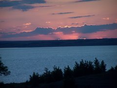
This morning we left Florence around 9:30 headed south on US 101 traveling along tree lined hills and curves with the Dunes between us and the ocean so saw very little of the ocean. At Coos Bay we took a 12 mile side trip to see Cape Arago Light House. When we got there it was about a mile across the bay so not accessible. Just about a mile further we came to Simpson Reef and had a wonderful view of the Sea Lions on the rocks between the shore and the reef. Unfortunately the road didn't continue on to US 101 so we had to get turned around and retrace our drive back to Coos Bay. Turning back south on 101 it was more trees gentle curves and hills with no view of the ocean.
About 25 miles on south we passed through the town of Bandon and began seeing cranberry bogs along the hi way. Nearing Port Oxford we began seeing the surf pounding against the rocky shores as we traversed the winding mountainous road. As we entered Gold Beach we crossed the Rouge River on the LL Paterson Memorial Bridge. This bridge built in 1931 was the first in the country to be built with prestressed concrete. After driving only 150 miles we stopped at the Turtle Rock RV Park where Hunter Creek enters the ocean. We spent a little time in town this afternoon at a Myrtle wood shop and at a book store that has over 80,000 books in stock. We missed the turn offs to two light houses that are accessible today so we didn't get to see all of the light houses along the Oregon coast.

Sunday, October 4, 2009

Florence, OR


This morning we headed south on US 101 by car after about 30 miles we came upon the Umpqua River Light House. This light house marks the area where the Umpqua River reaches the Ocean. This river is navigable about 30 miles upstream by fairly large vessels. This is a carbon copy of the Heceta Head light house. It is still an active light house and there is a really good museum located here in one of the original light keepers residences. This is in the Oregon Sand Dunes area so it is very sandy here. In 1861 and 1863 floods severely eroded the sandy hill where it was located and it was deemed unsafe. In the winter of 1863 crews very carefully removed the lens and equipment, it then toppled into the ocean in Feb. of 1864. It was not rebuilt until 30 years later when they decided that the traffic up and down the river justified it.

The Oregon sand dunes are along the ocean from here at Florence to about 150 miles further south. They are constantly changing due to the constantly moving sand. About 50% of them are set aside for the use of off road vehicles. We saw hundreds of them using them today. After having a late lunch in a little cafe along the pier in Winchester we spent an hour or so going through the Umpqua river Discovery Center.

Saturday, October 3, 2009

Florence, OR


This morning the sound of rain woke me around 5 AM. We have had rain everyday for the last week or more, they say that is normal for Oct. on the Oregon Coast. Temps have been in mid 60's daytime and mid 40s' nights. Mid morning we headed back north by car on US101 to see some of the things that we passed by yesterday. Our first stop was the Heceta Head light house (top photo) about 12 miles north of Florence. It was first illuminated in 1894 and could be seen 21 miles from land.
Moving further north our next stop was Yaquina Bay Light House (lower photo) at the north end of the Yaquina Bay Bay Bridge at Newport. This is the second oldest standing light house on the Oregon Coast. It was in service only from 1871 to 1874 when it was replaced by the Yaquina Head light house 3 miles up the coast. It is the only wooden light house on the Oregon Coast. It has been restored and is maintained by friends of Yaquina Bay Lighthouse. Moving on north across Newport we saw the Yaquina Head Light house (middle photo) that was first illuminated in 1873. It could be seen 20 miles from the coast compared to the 10 miles of the Yaquina Bay light house that it replaced. It is currently still in service, however it is now illuminated electrically instead of by oil as originally powered. Before leaving Newport we drove through the historic bay area, an area along the Bay that consists of small old store buildings on one side of the street and on the bay side old cannery buildings & piers that are being restored. This is a real tourisy area. We stopped at many scenic views as we moved back south. One of the most impressive was Cape Perpetua Scenic Area where we saw an long narrow area where the surf came up into the rocks known as the Devils Churn. Also in this area we saw Cooks Chasm as well as 100's of sea lions. We also got a very good picture of the Heceta Head Light House from here.

Friday, October 2, 2009

Florence, OR

After nursing a really sore knee for 5 or 6 days we are on the road again. After walking to the Cape Mears Light House on Fri. my right knee became extremely week and sore. Tues I went to the walk in clinic and on Wed. I received a shot of cortisone. Thur. we went to Astoria and walked through the cannery at pier 39 and ate lunch. On the return drive to the motor home we stopped at an antique store and a blown glass shop that Nancy had been wanting to go to. This morning we headed south on US 101 past the rocky coast north of Tillamook and then through the mountain meadows to the south that were full of dairies. From there on we had many beautiful views of the coast with the surf and waves splashing onto the rocky shores.
I believe the surf was much more violent and the waves much higher today than we had seen them earlier this week. Passing on through the towns of Newport, Yachats, Waldport and many other small coastal towns we were in and out of the coastal mountains and rocky shores. What a beautiful drive this was. Tomorrow we plan to drive back north in the car so that we can enjoy some of these areas and light houses.